Mongy geography
|
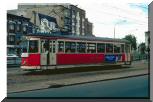
Cette ligne est en fait une double ligne. Elle part actuellement de la station souterraine de Lille-Flandres, où elle est en correspondance avec la gare SNCF du même nom, et avec les 2 lignes de métro. L'essentiel de son parcours est en site propre, tout au long du Grand Boulevard de Lille à Roubaix et Tourcoing. Le tramway ne roule jamais sur la chaussée au milieu des voitures. Ceci explique largement son maintien, et montre le modernisme de ses concepteurs. Il y a d'abord un tronc commun jusqu'à Marcq en Baroeul, en un lieu nommé Croisé-Laroche (alias place Lisfranc). Là la ligne se divise en 2 branches : l'une vers Roubaix, l'autre vers Tourcoing. Depuis 1974, on a installé dans le square de la place Lisfranc une boucle de retournement qui permet à certains tramways de ne pas aller au-delà et de revenir sur Lille. Le tronçon Lille-Croisé est donc beaucoup plus desservi que les tronçons au-delà. A hauteur du Croisé-Laroche,
se détachait une ligne assez courte qui allait par l'avenue
Foch à la place de Marcq (place De Gaulle), terminus à
hauteur de l'église St Vincent. Cette section a été
fermée en septembre 1972. Cette géographie
a subi au fil du temps diverses modifications. La description ci-dessus
est la situation actuelle. Autrefois, aux 3 terminus le tramway parcourait une boucle qui le faisait toujours rouler dans le même sens. Il ne repartait jamais en sens inverse. A Lille, il décrivait une boucle autour du grand théâtre de l'Opéra, sur le côté duquel se trouvaient des voies de passages, et des quais de départ différenciés pour Roubaix, Tourcoing et Marcq, plus un bâtiment de service. Cet aménagement était bien conçu, avec malgré tout un défaut : être à plusieurs centaines de mètres de la gare SNCF. Lors de construction du métro, on a construit le souterrain actuel qui permet au tramway d'arriver sous la gare de Lille-Flandres. Un arrêt dessert également la gare TGV de Lille-Europe. Mais sans boucle. A Roubaix le tramway faisait le tour de la place de l'hôtel de ville, par la place de la Liberté (lieu du premier terminus jusqu'en 1954), la Grand-Rue, et la rue du maréchal Foch. Il desservait bien le centre ville, sans aller non plus jusqu'à la gare SNCF. Un autre tramway jusqu'en 1956 y conduisait (puis un bus). A Tourcoing, le tramway décrivait sa boucle autour de l'église St Chritophe, également bien au centre de la Cité, pas très loin non plus de la gare SNCF. Depuis, à Roubaix comme à Tourcoing, on a supprimé ces boucles (je me demande pourquoi), et reculé un peu le terminus du tramway par rapport au centre des villes. Je ne pense pas que ce soit un plus. Quoique depuis 1999, la mise en correspondance dans ces 2 villes avec la nouvelle ligne du métro soit un progrès. Le terminus de Marcq, à hauteur de l'église St Vincent, a été en boucle, puis transformé en une simple voie unique. Le tramway, souvent une motrice 200 dans les années soixante, repartait en sens inverse. Une correspondance existait à cet endroit avec les gros tramways verts de la CGIT (ligne J supprimée en 1963) terminus de leur ligne ici également, venant de Lille comme le Mongy, par d'autres chemins (La Madeleine et RN 17). |
This line is in fact a double line. It now leaves the underground station of Lille-Flandres, where it is in correspondence with SNCF railway station of the same name, and with the 2 subway lines. The essence of its course is in exclusive right of way, throughout the Grand Boulevard from Lille to Roubaix and Tourcoing. The tram never runs on the roadway in the medium of the cars. This largely explains its maintenance, and shows the modernism of its originators. There is initially a joint base until Marcq en Baroeul, at Croisé-Laroche named place (alias Lisfranc square). There the line is divided into 2 branches: one towards Roubaix, the other towards Tourcoing. Since 1974, there is in the public garden of the Lisfranc square a loop of reversal which makes possible for some trams not to go beyond and to return on Lille. The Lille-Croisé section is thus served much more than the sections beyond. At
Croisé Laroche, was detached a rather short line which went
by the Foch avenue to the square of Marcq (place De Gaulle), terminus
by the church St Vincent. This section was closed in September 1972.
This
geography underwent in the past various modifications. Description
above is the current situation. Formerly, at the 3 termini the tram traversed a loop which always made it run in the same direction. It never set out again in opposite direction. In Lille, it described a loop around the large theatre of the Opera, on the side of which there were sidings, and starting platforms differentiated for Roubaix, Tourcoing and Marcq, plus a building of service. This installation was well conceived, with despite everything a defect: to be to several hundred meters of SNCF railway station. During construction of the subway, was built the current underground which makes now possible the tram to arrive under the railway station of Lille-Flandres. A stop served the TGV station Lille-Europe. But without loop. In Roubaix the tram was running around the town hall square, by the square of Freedom (place of the first terminus until 1954), the Main street, and the street of the Foch marshal. It served the centre town well, without going either to SNCF railway station. Another tram until 1956 led to it (then a bus). In Tourcoing, the tram described its loop around the church St Chritophe, also well in the center of the City, not very far either from SNCF railway station. Since, in Roubaix as in Tourcoing, were removed these loops (I wonder why), and moved back a little the terminus of the tram away from the center of the cities. I do not think that it is a good idea. Though since 1999, the connection in these 2 cities with the new line of the subway is a progress. The terminus of Marcq, by the church St Vincent, was a loop, then was transformed into a simple single track. The tram, often a motor coach 200 in the Sixties, set out again in opposite direction. A correspondence existed at this place with the large green trams of the CGIT (line J removed in 1963) terminus of their line here also, coming from Lille like Mongy, by other ways (the Madeleine and RN 17). |
Plan du réseau en 1994 - Map of the network in 1994
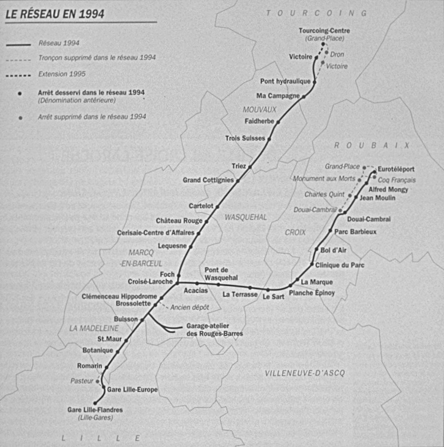
(extrait
du livre de Gérard Blondeau)